We are pleased to share with you actual testimonials of TNP users. Over the years we have been impressed with the variety of uses our customers find for TNP. This page is dedicated to our customers and their stories. If you have an interesting use of TNP you would like to share with the community, please send it to TNPsales@trimble.com.
"I use TNP in my environmental consulting business. It is an invaluable tool that enables me to highlight and pinpoint a specific street address where I perform environmental cleanup operations and send the map to the NJDEP along with the rest of the final report."
Joe M., Environmental Consulting
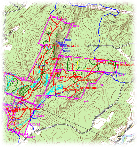
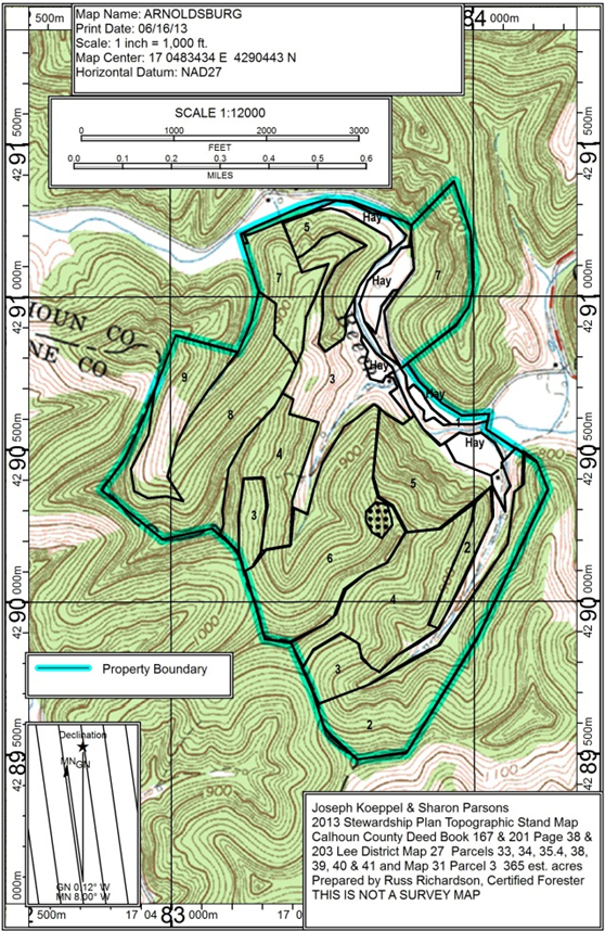
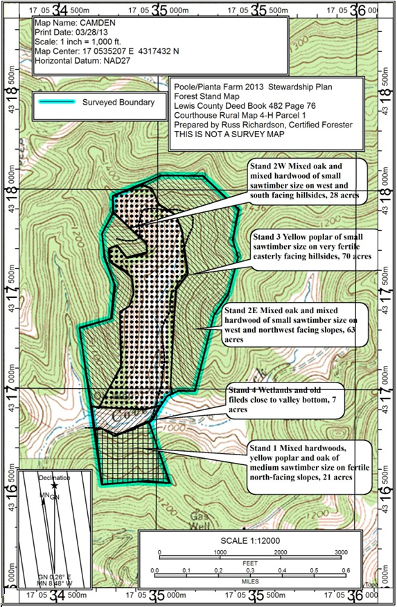
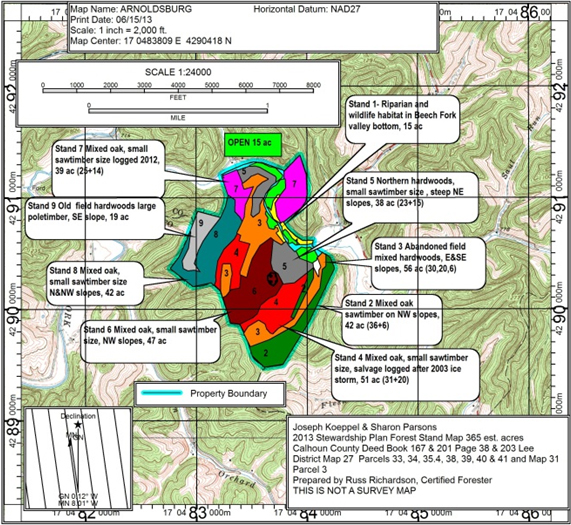
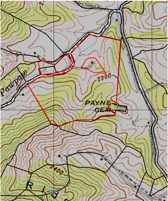
"I use TNP to map, collect data, and manage a 600 acre tree farm. I map trails, gates, culverts, boundaries, and other points of interest, and am able to import GIS data created by my forester …delineating timber stands and other features. The screenshot below looks very busy but I usually filter out layers I don't need. I find TNP is easy to use, much more cost effective than ARCgis for a personal user like myself, and it works well to collect data from various sources. I've been using the p"..."I use TNP to map, collect data, and manage a 600 acre tree farm. I map trails, gates, culverts, boundaries, and other points of interest, and am able to import GIS data created by my forester …delineating timber stands and other features. The screenshot below looks very busy but I usually filter out layers I don't need. I find TNP is easy to use, much more cost effective than ARCgis for a personal user like myself, and it works well to collect data from various sources. I've been using the program almost 12 years now and love all the improvements that have been made over that time."
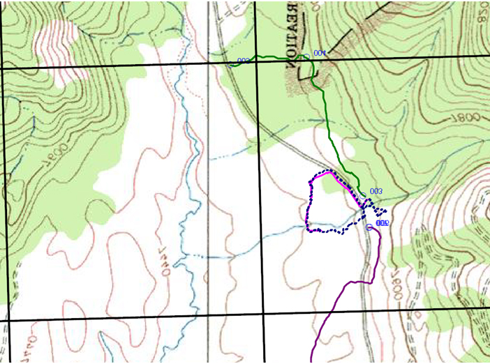
"Terrain Navigator is extremely valuable to us in Search and Rescue. We use it for training our k9's and humans as we can put in areas that must be searched and completely covered. We train people how to put in coordinates/waypoints into their GPS (or load it from our TN for them) and then the person and k9 go out and completely cover the area to see if anyone is there. This is exactly what we do on searches and afterwards we download the tracks into the TN map system and we can see exactly what "..."Terrain Navigator is extremely valuable to us in Search and Rescue. We use it for training our k9's and humans as we can put in areas that must be searched and completely covered. We train people how to put in coordinates/waypoints into their GPS (or load it from our TN for them) and then the person and k9 go out and completely cover the area to see if anyone is there. This is exactly what we do on searches and afterwards we download the tracks into the TN map system and we can see exactly what has been cleared of a person.
"I have been using TN for more than 10 years and it keeps getting better and my maps are getting correspondingly better."
Russ R., Certified Forester and Real Estate Broker
"I use TNP and my previous version, TNS, as visual aids in complaints I have field with federal and State of California agencies vested with oversight of salmonid anadromous fish listed under the federal Endangered Species Acts and suspected violation of the California Fish and Game Code, Regional Water Quality Control Board Basin Plan and the like."
Robert Z.
"I have used Terrain Navigator Pro for many years and found it to be an invaluable tool in my real estate appraisal business. A large part of my real estate appraisal work involves appraising improved and vacant large acreage tracts in the mountains of western North Carolina. Terrain Navigator makes it much easier for me to both find the general ownership lines for the properties that I’m appraising and plot and find the location of the sales of properties that I have chosen to use as compariso"..."I have used Terrain Navigator Pro for many years and found it to be an invaluable tool in my real estate appraisal business. A large part of my real estate appraisal work involves appraising improved and vacant large acreage tracts in the mountains of western North Carolina. Terrain Navigator makes it much easier for me to both find the general ownership lines for the properties that I’m appraising and plot and find the location of the sales of properties that I have chosen to use as comparisons in my appraisals. Ease of use is enhanced by the excellent visual appearance of TNP’s USGS maps that have consistently been the on-screen equivalent of paper USGS maps and are superior to the digitized version of those maps from any competing software product that I have used, including DeLorme’s Topo program.
Property line identification has been significantly enhanced by TNP’s feature allowing the importing of shape files which are now available from most of the GIS offices in the various western NC counties where I work. The GPS tracking function in TNP is also extremely useful as it identifies where I am in relation to either the property I’m appraising or the sale comparables. Google Earth integration has also been quite helpful. Lastly, the support provided by TNP staff in answering questions about the program has always been fast, accurate and professional. I would strongly recommend Terrain Navigator Pro to anyone."
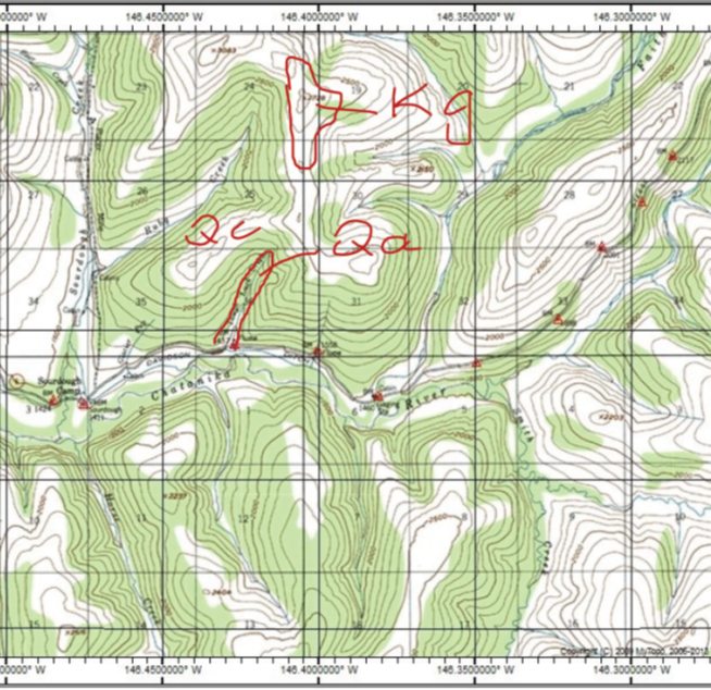
"I am a retired Geological Cartographer but I am still involved in field work. I am using TNP in the field to map the geology of an area. First I prepare the map in TNP on my laptop at home and export the map to my GIS program. I also export a jpg image of the map and transfer it to my iPad. I am using the iPad in the field to map directly on the screen using a stylus and record sample stations from the GPS. I am working in very remote areas and most of the time I am hundreds of miles from the ne"..."I am a retired Geological Cartographer but I am still involved in field work. I am using TNP in the field to map the geology of an area. First I prepare the map in TNP on my laptop at home and export the map to my GIS program. I also export a jpg image of the map and transfer it to my iPad. I am using the iPad in the field to map directly on the screen using a stylus and record sample stations from the GPS. I am working in very remote areas and most of the time I am hundreds of miles from the nearest cell phone connection so I have to have everything working without being connected to the internet.
To do my work I have to open a jpg of a map in an App called Notes Plus. I do my field sketches and take notes directly on the image and save it as pdf. I record sample stations from the GPS and mark them manually on the map image. The real marker is recorded in the GPS for later retrieval. With the iPad I can take pictures of geological outcrops and write on the photo and save as pdf.
Back at home I open the real geo-referenced map in my GIS software and transfer the GPS data points from the GPS.
So I use TNP for pre-field planning and printing field maps. In the field I work on images and later transfer the data to the GIS."
"I have been using Terrain Navigator Pro since 2005.
The TNP software is the best- It's the top of the line of recreational mapping software and venturing into the realm of professional surveying software. I found the price more than reasonable for the quality of product received.
I have completed several volunteer projects using TNP and I have received awards for those projects. You will find letters of reference to those events attached. Two particular projects would have b"..."I have been using Terrain Navigator Pro since 2005.
The TNP software is the best- It's the top of the line of recreational mapping software and venturing into the realm of professional surveying software. I found the price more than reasonable for the quality of product received.
I have completed several volunteer projects using TNP and I have received awards for those projects. You will find letters of reference to those events attached. Two particular projects would have been unfinished had I not had TNP. Other recreational software maybe cheaper, but it cannot/could not perform the tasks. The software I was dealing with that TNP helped a lot is ESRI. Not sure the specific program in ESRI, but the recreational software could not keep the data in a format that is importable into ESRI. If you've ever worked with the USFS, you may know what I'm talking about.
1. Continental Divide Trail Alliance has since disbanded after they completed their mission goal. There are a variety of similar groups that have since adopted the Continental Trail System in their respective areas. That project was the Cottonwood Pass Trail Re-Alignment. I assisted in the trail work, though my primary job there was to document their work for the USFS and I mapped the work done as well as other trails in the area that were considered for closure.
2. I was a member of the Lake County Search and Rescue in Leadville Colorado for a couple years, and in that time frame I re-mapped the county roads. LCSO had the roads on 2D county plats, and they had USGS topographical maps, but the mapping I performed updated the older maps as well as placed them on both 7.5 minute topographical maps and on the aerial photos provided by TNP.
3. I volunteered with the USFS (Pike/San Isabel District Office in Salida Colorado) mapping unauthorized two-track roads & ATV trails. Those maps were used to help implement trail damage remediation practices and monitor the unimproved/dispersed campsites as well as document fire hazards in the area.
If TNP was not there, none of the work I did would have been completed."
"I own Billbarrettsguideservice.com and use GPS on all hunting, snowmobile, moose, and bear hunting trips, coyote hunting trips. When I get home I print them on my computer off of Terrain Navigator in color to show clients for future trips."
Bill B., NH Guide
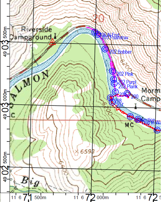
"We are a volunteer Canine Search/Rescue group. We carry a laptop and portable printer in one of the vehicles...running from an inverter, using Terrain Navigator Pro to generate local maps on-site for searches, and to gather GPS tracks from the individual teams to ensure that all areas have been covered. Alerts and clues found are also way-pointed, to provide more information to the Incident Command in directing the search."
Mike M., Canine Alert Search Teams
"My wife and I have the strange hobby of going out searching in the field for both NGS stations (described below) and the BLM marks. I can click on the BLM orange corners to create BMs in your application. I then down load the coordinate file to an Excel spreadsheet to determine the 1/2 ways along the lines for coordinates of 1/4 section corners. I upload the 1/4 corner coordinates to you application. Then I download the entire coordinate file for an area to my Lowrance iFinder GPS device. Gets u"..."My wife and I have the strange hobby of going out searching in the field for both NGS stations (described below) and the BLM marks. I can click on the BLM orange corners to create BMs in your application. I then down load the coordinate file to an Excel spreadsheet to determine the 1/2 ways along the lines for coordinates of 1/4 section corners. I upload the 1/4 corner coordinates to you application. Then I download the entire coordinate file for an area to my Lowrance iFinder GPS device. Gets us what we need to go searching. All and all it is very accurate. We search in both New Mexico, where things are a lot easier to find and in North Carolina where all we can look for is NGS monuments -- a direct download to GPS as you know.
I have a GPS antenna for the lap-top but that is just too awkward for us to use in the field. Plus no 3 mile long power cords that are convenient.
So the data on your maps help a lot. The only calculations are the 1/4 corners for BLM land.
Oh, there are monuments at each 'corner' of the Blueridge Parkway NPS land. A corner being just a turn in the straight line. We can BM those points on Terrain Navigator pro, and download them to the handheld GPS. Give use something healthy to do together with the dog. If we only could teacher the golden retriever to sniff these things out that would be good too.
Sometimes we take the downloaded points from your application and change them to KMLs for Google Earth. But if we print those it is just too much paper for the field. Though I am always printing your maps from TNP and 1:12,000 to help.
Just giving you the view from a lightweight recreational user.
"We are using TNP for documenting searches and training for wilderness search and rescue in central Idaho."
David L.
"[From] an article I published in the Bulletin of the Mass. Archaeological Society. It is a study of astronomically aligned features in and around a wetland. TNP was an important tool in my work. I use it constantly in my work supporting Indian tribal efforts to preserve ancient ceremonial places."